Google Maps implementation - Service Portal
- Mark as New
- Bookmark
- Subscribe
- Mute
- Subscribe to RSS Feed
- Permalink
- Report Inappropriate Content
01-29-2020 04:42 AM
Hi guys
I am implementing the google maps API on the portal, however to call it, it is necessary to place the code inside a <script> tag in HTML instead of using the common client script. The problem is that I need to pull information from tables in the servicenow to put on the map, so ideally I would be able to access the data object, from the <script> tag. I tried to use UI script with GlideAjax and the client's GlideRecord, but this type of call just doesn't work from the service portal.
Can someone help me?
I thank you for your attention, have a good day !!!
- Mark as New
- Bookmark
- Subscribe
- Mute
- Subscribe to RSS Feed
- Permalink
- Report Inappropriate Content
03-04-2020 08:06 PM
Ok...so it's been more than a few days. I should probably do a proper article for this. And I might. In a few days. 🙂 Here's the end result in the form of a widget:

I used leaflet.js for this project. For the marker positions, I just used the demo records in my personal dev instance's location table. They have latitude and longitude values.
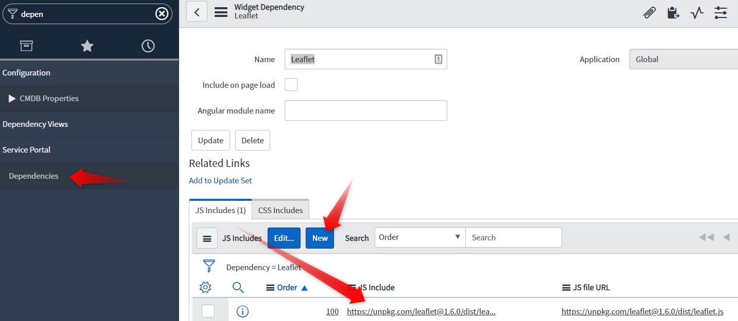
First thing I did was create a new widget dependency named Leaflet. Then I created a new JS include that points to the URL of the of the leaflet library (https://unpkg.com/leaflet@1.6.0/dist/leaflet.js). Though, it would be better to have a local copy of the library for your JS include.


I had to grab a copy of the marker image as well:

Now we can build our widget. So create a new widget with the following:
HTML
<div id="mapid" style="height: 580px"></div>For the CSS, go to https://unpkg.com/leaflet@1.6.0/dist/leaflet.css and copy/paste that.
Server script
(function() {
	var location = [];
	var gr = new GlideRecord('cmn_location');
	gr.query();

	while (gr.next()) {
		var o = {};
		o.latitude = gr.latitude.toString();
		o.longitude = gr.longitude.toString();
		o.name = gr.name.toString();

		location.push(o);
	}

	data.locmarker = new global.JSON().encode(location);
})();
Client controller
function($scope) {
    /* widget controller */
	var c = this;
	var m = JSON.parse(c.data.locmarker);

	console.log('RGP: ' + m[0].latitude);

	var mymap = L.map('mapid').setView([33.738045, -84.358662], 5);

	L.tileLayer('https://api.mapbox.com/styles/v1/{id}/tiles/{z}/{x}/{y}?access_token=pk.eyJ1IjoibWFwYm94IiwiYSI6ImNpejY4NXVycTA2emYycXBndHRqcmZ3N3gifQ.rJcFIG214AriISLbB6B5aw', {
		maxZoom: 18,
		attribution: 'Map data copy; <a href="https://www.openstreetmap.org/">OpenStreetMap</a> contributors, ' +
		'<a href="https://creativecommons.org/licenses/by-sa/2.0/">CC-BY-SA</a>, ' +
		'Imagery © <a href="https://www.mapbox.com/">Mapbox</a>',
		id: 'mapbox/streets-v11',
		tileSize: 512,
		zoomOffset: -1
	}).addTo(mymap);

	for (var i=0; i<m.length; i++) {
		L.marker([m[i].latitude, m[i].longitude]).addTo(mymap)
			.bindPopup(m[i].name);
	}

}
As you can see in the client script above, I just, more or less, pasted in leaflet's example. It's probably advisable to get your own token.
Lastly, link the dependency you created to this widget:

And that is that.
- Mark as New
- Bookmark
- Subscribe
- Mute
- Subscribe to RSS Feed
- Permalink
- Report Inappropriate Content
10-10-2022 04:11 AM
Hello Roger, do you by any chance remember how you added the markers? Cause my map doesn't seem to pick them up even even though I added the marker to the image table.
- Mark as New
- Bookmark
- Subscribe
- Mute
- Subscribe to RSS Feed
- Permalink
- Report Inappropriate Content
11-22-2022 07:53 PM
Hey @Amal Catalin
Sorry, I didn't see this until now. Were you able to figure it out? If you still need some help, I'll reach into the deep parts of my brain and see what I can find.
Let me know
-Roger