Plotting Custom Table geopoint Data on Map Report
- Mark as New
- Bookmark
- Subscribe
- Mute
- Subscribe to RSS Feed
- Permalink
- Report Inappropriate Content
04-27-2024 12:21 PM - edited 04-29-2024 12:07 AM
I'm working on creating a map report in ServiceNow that displays geolocation data from a custom table. This table stores location data in a single field named "geolocation" with the geopoint type (latitude, longitude) along with other relevant fields.
My objective is to:
- Create a map source that utilizes the "geolocation" field to extract latitude and longitude values.
- Plot the records from this table on a map type report.
I'd appreciate any guidance on the following:
- Map Source Configuration: Can you advise on the specific steps to configure a map source that parses the (latitude, longitude) data from the "geolocation" field in my custom table?
Map Report Setup: Once the map source is created, what configurations are required within the map report to display the custom table data effectively?
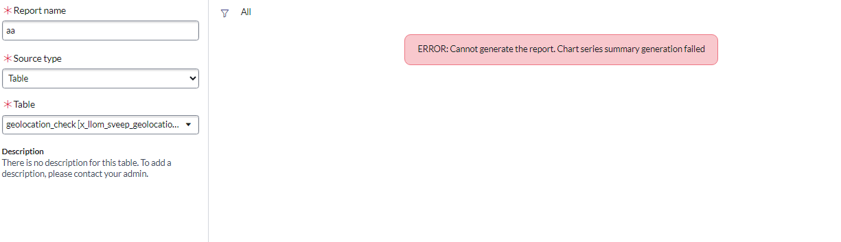
I have prepared a sample table, map source and corresponding report error for reference.
- Mark as New
- Bookmark
- Subscribe
- Mute
- Subscribe to RSS Feed
- Permalink
- Report Inappropriate Content
04-28-2024 03:34 PM
@KumarA913649730 Please look at the below post which might help you in configuring the reports-
https://www.servicenow.com/community/platform-analytics-forum/kingston-map-report-is-populating-only...
If my response has resolved your query, please consider giving it a thumbs up and marking it as the correct answer!
Thanks & Regards,
Sanjay Kumar Gupta
- Mark as New
- Bookmark
- Subscribe
- Mute
- Subscribe to RSS Feed
- Permalink
- Report Inappropriate Content
04-29-2024 12:02 AM
Hi, thanks for responding. But, the responses in the post is not helping as it is also based on the existing tables.
the records in my custom table are created by 1000+ users who go to their target location and provide information along with recording their current geolocation position.
I checked the other map sources, related to Incident table etc. but the location there refer to a reference table cnm_location. my table format is a bit different and only has a geolocation field. Adding it to the map sources, and generating chart results in error.
i have prepared a sample table and corresponding report error for reference. attaching in the original post.