Remote Sensing
While numerous recent benchmarks focus on evaluating generic Vision-Language Models (VLMs), they fall short in addressing the unique …
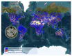
This paper presents EarthView, a comprehensive dataset specifically designed for self-supervision on remote sensing data, intended to …

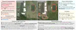
Geospatial Information Systems are used by researchers and Humanitarian Assistance and Disaster Response (HADR) practitioners to …

Applications such as disaster management enormously benefit from rapid availability of satellite observations.
Traditionally, data …
Recent progress in self-supervision shows that pre-training large neural networks on vast amounts of unsupervised data can lead to …

Remote sensing and automatic earth monitoring are key to solve global-scale challenges such as disaster prevention, land use …
Cattle farming is responsible for 8.8% of greenhouse gas emissions worldwide. In addition to the methane emitted due to their digestive …
We paired existing land use regression (LUR) models for ambient ultrafine particles in Montreal and Toronto, Canada with satellite …
Here we present a new method of estimating global variations in outdoor PM2.5 concentrations using satellite images combined with …